Input Data file 'F16.ch10'
Chan 6  RT 4  TR 1  SA 16  INS Position/Attitude

               Raw INS    Raw INS    INS
              Longitude  Latitude   Data     INS      True     Roll     Pitch           Ground
    Time      (+ East)   (+ North)  Valid  Altitude  Heading  (+ Right) (+ Up  )        Speed
   (UTC)      (- West)   (- South)          (MSL)             (- Left ) (- Down)   G's   (kts)
21:24:00.091  -86.747795  30.511623   1     9268      68.2   -12.975    10.091    1.013  312.4
21:24:00.291  -86.747485  30.511732   1     9276      66.7   -27.044     9.778    0.934  312.1
21:24:00.491  -86.747175  30.511843   1     9284      64.9   -41.557     9.113    0.937  312.0
21:24:00.691  -86.746867  30.511955   1     9288      63.0   -54.296     8.537    1.106  311.7
21:24:00.891  -86.746561  30.512071   1     9296      60.7   -65.112     8.218    1.266  311.5
21:24:01.091  -86.746257  30.512190   1     9300      58.1   -72.567     8.026    1.458  311.3
21:24:01.291  -86.745956  30.512314   1     9304      55.3   -76.731     7.779    1.702  311.0
21:24:01.491  -86.745658  30.512443   1     9308      52.6   -78.533     7.361    1.934  310.6
21:24:01.691  -86.745364  30.512578   1     9312      49.8   -79.005     6.790    2.140  309.9
21:24:01.891  -86.745075  30.512719   1     9316      47.1   -79.346     6.076    2.294  309.2
21:24:02.090  -86.744791  30.512867   1     9320      44.5   -80.395     5.208    2.452  308.5
21:24:02.291  -86.744513  30.513021   1     9320      41.8   -82.208     4.180    2.589  307.5
21:24:02.491  -86.744242  30.513183   1     9320      38.9   -84.202     3.098    2.747  306.6
21:24:02.690  -86.743978  30.513351   1     9320      35.8   -85.690     2.076    2.818  305.4
21:24:02.890  -86.743723  30.513528   1     9320      32.9   -86.641     1.132    2.923  304.0
21:24:03.090  -86.743476  30.513711   1     9320      30.0   -87.300     0.225    3.014  302.6
21:24:03.291  -86.743239  30.513902   1     9316      27.3   -87.657    -0.676    3.092  301.1
21:24:03.490  -86.743011  30.514099   1     9312      24.7   -87.783    -1.533    3.090  299.5
21:24:03.690  -86.742794  30.514303   1     9308      22.2   -87.723    -2.280    3.087  297.8
21:24:03.891  -86.742586  30.514512   1     9304      19.8   -87.234    -2.950    3.089  296.2
21:24:04.090  -86.742390  30.514727   1     9296      17.5   -86.635    -3.505    3.011  294.5
21:24:04.290  -86.742204  30.514947   1     9288      15.2   -86.037    -3.972    3.023  293.0
21:24:04.491  -86.742030  30.515172   1     9276      13.1   -85.229    -4.395    2.942  291.3
21:24:04.691  -86.741865  30.515401   1     9268      10.9   -84.312    -4.724    2.908  289.8
21:24:04.891  -86.741713  30.515635   1     9256       8.8   -83.306    -4.939    2.904  288.4
21:24:05.091  -86.741571  30.515872   1     9244       6.7   -82.164    -5.092    2.845  287.0
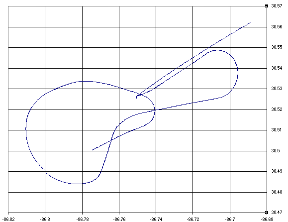
It's easy to import this file into Microsoft Excel. Then graphing the latitude and longitude
quickly produces to plot of aircraft position.
The -g flag can be used to specify a reference position on the ground. More than one reference position can be specified by using multiple -g flags. When one or more reference positions are defined, the INS output will also include position and attitude information relative to that point. The -m flag can be used to only dump INS data points when within a prescribed distance from the reference point.
The -T flag can be used to dump a brief TMATS summary of the data file to help in choosing command line parameters.
Usage: idmpins <input file> <output file> [flags]
   <filename>       Input/output file names
   -v               Verbose
   -a               Dump aircraft INS attitude
   -c Bus           IRIG Channel Number
   -r RT            INS RT Address(1-30) (default 6)
   -t T/R           INS T/R Bit (0=R 1=T) (default 1)
   -s SA            INS Message Subaddress (default 16)
   -d Num           Dump 1 in 'Num' messages (default all)
   -i Type          INS Type (default 1)
                      1 = F-16/C-130/A-10 EGI
                      2 = F-15
   -g Lat Lon Elev  Ground target position (ft)
   -m Dist          Only dump within this many nautical miles
                      of ground target position
   -T               Print TMATS summary and exit